 |
| Kansas City skyline from Kaw Point at 7am. |
Memorial Day weekend we made our longest trip yet on the Mighty MO: 51.5 miles from Kansas City (Kaw Point) to Lexington, Missouri. It was hot (94 degrees), which is great training for the MR340 race in late July. We finished our trip in 7 1/2 hours! Our average rate was 6.87 miles per hour, which is promising! During the actual trip we will need to average 5.56 miles per hour between Kaw Point and Lexington to beat the cutoff time.
This trip, we sought to really focus on navigating the river. "Navigating? Why would you need to navigate a river that goes straight?" We navigate the river not so we don't get lost, but so that we stay in the fastest channel possible. Fast channel = more mph = quicker finish = less time without sleep!
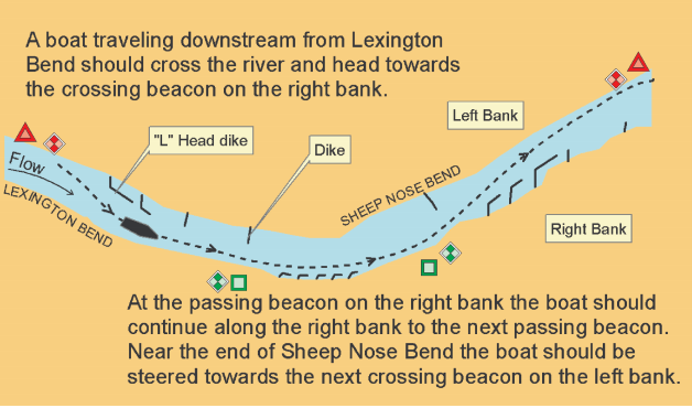
Although we do have printed maps that show us where to stay in the channel, we rely primarily on the channel makers used by the river barges. There are passing markers (stay on that side of the river) and crossing markers (cross to the other side of the river):


(source: MR340 Paddler, River Navigation)
In addition to the markers, we have to watch out for buoys and wing dikes. Buoys are 8-10 feet tall and are tied down by a chain in the river by a concrete block. These can be incredibly dangerous because they can move without notice if a tree becomes stuck on the chain, underneath the water, out of sight. Even more terrifying, they can become totally submerged and pop up without warning. Buoys can be red (should be on the left of the canoe) or green (should be on the right of the canoe).
Wing dikes, or wing dams, are human-made damns that protrude partially into the river. They slow the water near river banks to help decrease erosion. These too can become submerged, posing a danger for our kevlar canoe which would become punctured or shredded if we traveled over a partially submerged wing dike.
These dangers (buoys and wing dikes) and our desire to stay in the channel result in our canoe traveling down the Missouri River in a crisscross pattern: moving from the left side of the river (red markers) to the right side of the river (green markers):
This is why practicing on the Missouri River is important during our training. Although we miss the ability to splish splash in the water, we will be thankful come late July when navigating the Mighty Mo is second nature!
 |
| Sunset in Lexington, 51.5 miles downriver from KC. |
|
| Kansas City skyline from Kaw Point at 7am. |
 |
| Another selfie. |
 |
 |
| Very hard work, clearly. |
 |
| 7.5 hours and 51.5 later. Temperature in the mid 90s. |


No comments:
Post a Comment